Recent water trends have serious future implications. This warning once again highlights the importance of the State of Global Water Resources Report, published annually by the WMO since 2022. In its 5th edition, which was presented on 17 September 2026, it provides a semi-decadal overview of the status of global freshwater resources utilizing modelling, remote sensing and in situ observation-based data products. This 5th anniversary highlights the success and importance of the report, which helps in identification of hotspots at a global scale to inform planning and policy making and promotes monitoring and data sharing.
Over five editions, the report has expanded substantially in scope, methodology, data coverage and institutional engagement. The first edition, covering 2021, focused on three variables: river discharge, total water storage and cryosphere water resources. Even back then, the river discharge analysis in the report was based on in situ data received from WMO Members represented by NMHSs, primarily obtained via the GRDC database. Over the years it has expanded to 15 hydrological variables and the 2025 edition of this report was enhanced by the addition of new chapters on lake ice extent and water quality parameters. Data on soil moisture and water quality have been provided by our partner data centres the International Soil Moisture Network (ISMN) and the Global Freshwater Quality Database GEMStat, respectively.
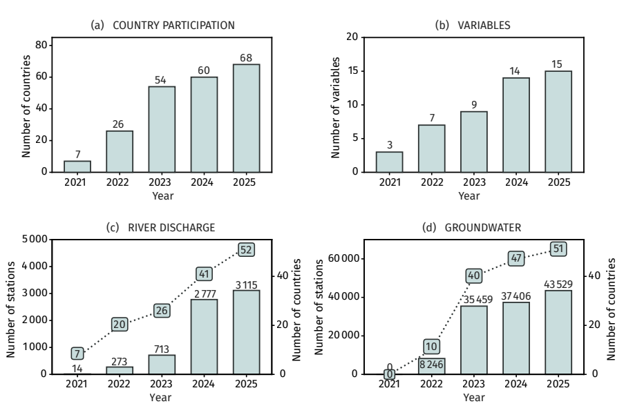
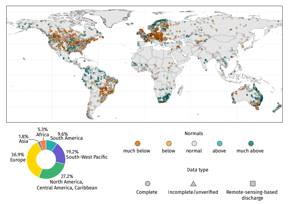
One of the most important developments over the five editions has been the growth in observed data contributions. The number of countries providing river discharge data increased approximately 7.5-fold, from 7 in 2021 to 52 in 2025, while the number of river discharge stations rose from 14 in the first edition to 3,115 in the current one. River discharge observations are now also complemented by data on a further ~500 stations derived from space-based observations that help to address spatial and temporal gaps. This expansion has been driven by the growth in Member participation and enabled, in parallel, by progressive improvements in the methods used to request, collect, process and integrate the data. However, Africa and Asia together accounted for only about 7% of the stations included in the assessment, while South America accounted for 10%.
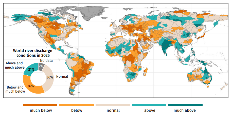
In its semi-decadal statement, the report shows that the share of global basin area experiencing normal discharge conditions has remained below the historical mean in each of the past seven years. Across the five reporting years, recurring below-normal river discharge was observed in major parts of the Amazon and La Plata basins, North America, Central and East Africa, Central Asia and the Middle East. Overall, 2025 was a dry year for river discharge worldwide, and one of the driest in 35 years (1991–2025). Annual river discharge in 2025 was above to much above normal across South, East and South-East Asia, parts of northern South America, and selected African and north-eastern and eastern Australian basins. Below- to much-below-normal river discharge affected several major regions, including much of North America, the La Plata and São Francisco basins of South America, Eastern European basins, the Middle East and Central Asia. Africa showed contrasting river discharge conditions, with above-normal flows in the Senegal, Niger, Lake Chad, Orange and Limpopo basins, but much-below-normal discharge in the Nile, Congo and Zambezi basins.
The report shows that water data availability has improved, but gaps remain especially in the areas most affected by water-related disasters such as Asia and Africa. Continued data sharing is therefore essential to improve the geographical representativeness and robustness of the global assessment, validate modelled and satellite-based information, and strengthen the evidence base for water resource management, early warning systems and climate adaptation actions. These efforts are also supporting the objectives of the Early Warnings for All (EW4All) initiative, the WMO Hydrological Observing System (WHOS) and the WMO Global Hydrological Status and Outlook System (HydroSOS). Together, these components form an end-to-end chain than ranges from observation and data exchange through operational status and outlook products to the annual global assessment provided in this report, all underpinned by the WMO Unified Data Policy.
Further information and the full report are available at the website of WMO.
Back to top