The demand for reliable discharge data for water-related research topics is increasing constantly. Quality-checked data of the national hydrological services form the basis, whether for the calibration or evaluation of hydrological models or the validation of remote sensing data.
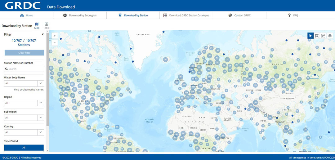
The GRDC Data Portal allows to search and visualise available runoff stations and time series data in map and table view. The data can be selected for single stations or for specific regions, subregions or countries. The data can be downloaded in various formats and complemented by subregion boundaries or watershed boundaries of GRDC stations.
To start a data download, select your subregion or stations of interest, click on the download button which appears, complete the form, choose your preferred export format and agree to GRDC’s Terms of Use, Data Protection Regulation and Data Sharing Conditions.
The GRDC Data Download portal is for web-based selection and download of river discharge data collected by GRDC on behalf of the World Meteorological Organization (WMO). All hydrological data offered here are managed by GRDC with permission of the data owners, usually the National Hydrological Services who created the data. All hydrological data remain property of the owner and are released only for research purposes.
Commercial use of the original data is not allowed. The redistribution of the downloaded data either in part or total to unauthorized persons, third parties or to the general public (incl. distribution via Internet) is not allowed.
Analysis and further processing of hydrological data as well as the use of statistical data products is permitted with an appropriate reference to the source of data as: “The Global Runoff Data Centre, 56068 Koblenz, Germany”.
With your data request and download you accept the terms of use and data sharing conditions as documented in the GRDC’s Policy Guidelines.
The GRDC Data Portal allows to download data in six different formats:
GRDC Export format (ASCII text):
Column-based, comma-separated text format especially developed to share GRDC discharge data, and associated metadata. It provides a series of time-value-pairs. The header of the file provides observation metadata like station name and number, water body, coordinates, upstream catchment size, etc. as well as time series metadata and provenance information.
Please note: GRDC calculated monthly values are the mean of original daily discharge values in the given calendar month. Minimum number of values in aggregation interval: 20.
GRDC Statistics format (CSV text):
Column-based, comma-separated text format especially developed to share GRDC primary statistics data, and associated metadata. Statistical values of the same type like yearly values, long-term values or seasonal values are compiled in one file. The header of file provides observation metadata like station, water body, coordinates, upstream catchment size, etc. as well as processing information.
NetCDF (binary format):
Exchange format of array-oriented scientific data in binary format, including file and variable metadata in key-value format.
More information is provided at https://www.unidata.ucar.edu/software/netcdf
Please note: Time is provided in days since 1700-01-01.
WaterML2 format (XML):
Standard exchange format for hydrological time series. Time series are provided as time-value-pairs, along with observation and time series metadata.
A brief summary of WaterML2 is given at: http://waterml2.org/
Please note: WaterML2 format is primarily developed for automatic processing, for example with Python, and not for viewing. However, you can open a wml2 file in your browser or use an XML-editor to examine your wml2 data.
ZRXP Exchange format (ASCII text):
Column-based text format used particularly for data exchange between WISKI systems. It provides a series of time-value-pairs and encrypted data quality information. The corresponding column definition and time series information is in the file header.
Station based watershed boundaries (GeoJSON file):
Catchment polygons are provided as GeoJSON files, an open standard format to share geographic features. GeoJSON is supported by various mapping and GIS software products as well as open source mapping tools. Please note: catchment polygons do not exist for all GRDC stations particularly for those which came to the GRDC dataset after 2011, when the majority of polygons were delineated.
You will receive a confirmation and a request ID. A download link will be sent within 24 hours to the email address you entered. Due to technical reasons, it may take a few minutes after receiving the download link before data is available on the server.
If you are facing difficulties in accessing the data, or how to download multiple stations at once, please have a look at our FAQs, the Navigation guide for GRDC data portal (available in English and Spanish) or contact GRDC directly at grdc@bafg.de. Please mention the request ID when making any inquiries about your download.
Navigation guide for GRDC data portal:
Back to top