Watershed boundaries are an essential basis for hydrological analyses, as they define the area contributing runoff to a gauging station and allow observations of river discharge to be related to their upstream catchment.
A catchment is commonly used as a spatial unit for studying and reporting hydrological processes. Its boundary is determined primarily by topography and defines the area from which water drains towards a common outlet. In the case of GRDC stations, this outlet corresponds to the location of the river gauging station.
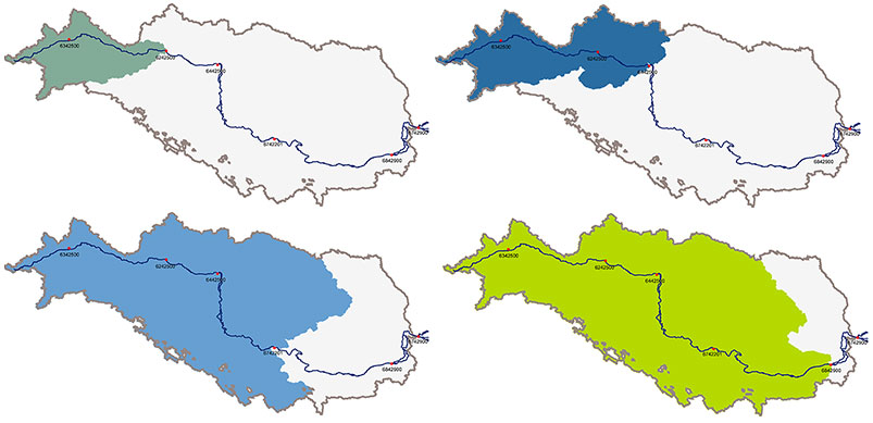
The widespread use of GIS in hydrology and environmental sciences has created a high demand for catchment polygons associated with river discharge observations. GRDC therefore provides watershed boundaries for approximately 99% of all stations contained in the Global Runoff Database.
Watershed delineation
The first comprehensive set of watershed boundaries for GRDC stations was generated in 2011 by Prof. Bernhard Lehner, McGill University, using the HydroSHEDS (Hydrological data and maps based on SHuttle Elevation Derivatives at multiple Scales) drainage network. GRDC remains grateful for this work and for the permission to make the generated watershed polygons available to users of the GRDC dataset. The original methodology is documented in Report 41 of the GRDC Report Series.
Since then, the number of stations available from GRDC has increased to more than 10,000 and the watershed dataset has been continuously extended and revised. With the current workflow, watershed boundaries are available for approximately 99% of all GRDC stations.
The current GRDC workflow combines watershed delineations based on *HydroSHEDS* and *MERIT Hydro / MERIT-Basins*. For each station, potential outlet locations within a 5 km buffer are generated and watershed boundaries are derived from the underlying hydrographic datasets. All possible watersheds are evaluated using the reported catchment area of the GRDC station and the distance between the station coordinates and the derived outlet.
Where both datasets provide suitable results, the watershed that best represents the GRDC station is selected. Automatic selection is restricted by defined quality criteria for the agreement in catchment area and the distance between the reported station location and the derived outlet. Cases for which an appropriate watershed cannot be selected automatically are inspected manually.
This combined approach makes it possible to benefit from the different characteristics of the global hydrographic datasets and to improve the representation of GRDC catchments, particularly where a single dataset alone cannot adequately represent the river network or station location.
The methodology for watershed delineation and the treatment of gauge locations is also described in Section 2.3, “Catchment polygons and gauge locations”, of the GRDC-Caravan publication by Färber et al. (2025).
For watershed delineation based on MERIT, GRDC uses the open-source delineator software developed by Matthew Heberger.
Acknowledgements
GRDC gratefully acknowledges the developers and organisations that provide the hydrographic datasets and tools on which the watershed product is based.
HydroSHEDS version 1 was developed by World Wildlife Fund (WWF), in partnership or collaboration with McGill University, Montreal, Canada; the U.S. Geological Survey (USGS); the International Centre for Tropical Agriculture (CIAT); The Nature Conservancy (TNC); the Australian National University, Canberra, Australia; and the Center for Environmental Systems Research (CESR), University of Kassel, Germany. Major funding for this project was provided to WWF by Diversey Holdings, Ltd.; additional financial support was provided by The Nature Conservancy, the International Union for Conservation of Nature (IUCN), the EU BioFresh project, and McGill University.
MERIT Hydro was developed by Dai Yamazaki and colleagues and provides a globally consistent representation of river networks and related hydrographic information. MERIT-Basins provides the corresponding global river basin framework.
GRDC also acknowledges Matthew Heberger for the development and publication of the open-source delineator software used for the MERIT-based watershed delineation.
Recommended citation
GRDC (2026): Watershed Boundaries of GRDC Stations, Global Runoff Data Centre, Koblenz, Germany, Federal Institute of Hydrology (BfG).
Download
The Watershed Boundaries of GRDC Stations are provided as GEOJSON files from the GRDC Data Portal (download all stations in monthly format) or can be accessed for the complete GRDC dataset in the following formats:
| Format |
|---|
| Shapefile (ZIP) |
| GEOJSON (ZIP) |